Inca Trail to Machu Picchu

 Not only did the Inca roads symbolize the power of the state around a space articulated by 23,000 Km of roads, the Qhapaq Ñan, but were also the link between the real and the supernatural, between the earth and the goals within a cultural universe spanning from the north of Argentina and Chile to the Venezuela plains.
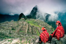
For the fit there is simply no substitute for traveling to Machu Picchu Inca City the way the Inca themselves did—on foot. Today the Inca Trail winds through the mountains and along the path of the ancient royal highway. More than 75,000 people make the trip each year and along the way experience some of the associated sites that were part of the Qhapaq Ñan in this area.
It’s no longer possible to do the trek independently. Due to heavy use (and subsequent environmental impact) the trail has become heavily regulated. Visitors must sign up with an organized group to tackle either the classic four-day route or a recently added two-day option.
On his first trip to the site Hiram Bingham walked for six days from Cusco. Today many choose to follow in his footsteps by hiking to the ruins on the legendary Inca Trail. It’s an experience like no other, but one no longer necessary.
The Inca Trail Trekking
Follow in the footsteps of the Incas by walking the trails used by them throughout the history of their empire.
At kilometer 88 of the Cusco - Quillabamba railways is Qorihuayrachina, the starting point of one of the most famous trekking routes in Peru. During four days of journey, trekkers cross various altitudes and environmental systems between 2,800 and 4,000 m.a.s.l., while at the same time enjoying a spectacular view of the most impressive glaciers in the region. Before reaching the Machu Picchu Inca City, the Inca Trail goes through the beautiful citadels of Phuyupatamarca and Wiñay Wayna among other 16 archeological compound. The 40 Km route ends at the relaxing hot springs in Machu Picchu Town (Aguas Calientes), 2 Km from the train station.
The circuit varies depending on the actual section you wish to go on. The most popular route starts at Km 82 on the Cusco - Machu Picchu railway line (40 Km from Machu Picchu Inca City). A less strenuous alternative is the Camino Sagrado (Sacred Path), which starts at Km 104 on the same railway line. Cusco It forms part of the network of Inca trails (Qhapaq Ñan). This is one of the most important trekking routes in South America. On the trek, hikers can see numerous ravines and flows of water that originate in glaciers. Among the 12 archaeological sites that can be visited, the following really stand out: Qoriwachayrachina, Patallaqta, Runkuraqay, Sayacmarca, Phuyupatamarca, Intipunku, Intipata and Wiñayhuayna. Only permitted the admission of 500 visitors per day, included the guides and porters.
Description of the Inca Trail to Machu Picchu route
Based on traditional 4 days / 3 nights tour.
The total distance of the trail is approximately 39.6 Km. and begins at Km. 88 at a place called Q'oriwayrachina. To begin the trail, you must cross the Kusichaca bridge, (an important Inca bridge which using Inca techniques, has been built with steel cables which allow visitors to cross the Urubamba River). Then you head over to the left bank through a Eucalyptus grove and start the day calmly.
Almost immediately, you will come across the archaeological complexes of Q'ente, Pulpituyoc, Kusichaca and Patallaca. From this last spot, follow the trail along the left side of the Kusichaca River in the area with the same name where you will not only see the bridge but also you will find tombs, aqueducts, terraces. roads and a canyon. Continue until you reach the small peasant village of Wayllabamba and Inca aqueducts. It takes around four hours to cover the 9 Km up to this spot. One can camp here for the first night, but for comfort we recommend staying in Llullucha 1.6 Km further on.
The second day is more difficult as the hiker will have to climb up to 4,200 meters, crossing the Warmiwañusqa pass, the first and the highest. If you suffer from "soroche" (altitude sickness) it is best not to stop and descend quickly to the valley of the Pakaymayu River, where you can camp. This spot is 7 Km away and an approximate eight-hour walk.
The third day is the longest but most interesting. You will be able to visit impressive archaeological complexes such as Runkuraqay, the second pass, at 3,800 meters above sea level. This is a walled complex with interior niches that perhaps was a small place for rest, guard post and worship place. After crossing the second pass, descend to Yanacocha (the black lagoon), to then climb up a path with stone steps until you reach another cluster of buildings which attracts the attention of visitors. This spot is called Sayaqmarka a pre Hispanic complex with narrow streets, buildings erected on different levels; shrines, patios, canals and a protecting outer wall. At the top of the buttress one can see many constructions which lead one to suppose they once were a temple and an astronomic observatory which had a permanent supply of water and excellent food storehouses.
Sayaqmarka is a place filled with mystery and enchantment. The approximate distance to Runkuraqay is 5 Km, which takes 2 hours. This complex lies at 3,600 meters above sea level. There are excellent paths and a tunnel through this complex. We recommend you camp near the Phuyupatamarca ruins or 3 Km further on at the Wiñay Wayna Visitors Center, where one can buy food and drinks or use the bathrooms. The Phuyupatamarca ruins are better preserved than those seen before now.
It has a solid base built down to several meters in some cases. The Wiñay Wayna ruins were given the name possibly because of the abundance of a beautiful type of orchid which flowers nearly year-round in the whole area. The Peruvian government and the Viking Fund signed an agreement in 1940 to investigate the area, and sent the Wenner Gren expedition led by Professor Paul Fejos. But despite the expedition, there is no precise information about the specific function of six groups of dwellings near Machu Picchu. They are divided up into four well-defined sectors which are: the agricultural sector with many terraces, the religious sector, the fountain sector and the residential sector where the houses are located.
On the fourth day, which starts around 8 A.M., the walker arrives at Machu Picchu Inca City at around 11 A.M. after 8 Km of hiking through the jungle. Follow the signaled route and drink some water at the Wiñay Wayna Visitors Center. The path is clearly marked but try to avoid getting too close to the cliff edge.
It is forbidden to camp in Inti Punko. Leave your equipment at the control gate and enjoy getting to know the most important monument in this part of ; the continent. You have time to walk around Machu Picchu until mid-after-noon.
Entrance Tickets
No entrance tickets for any of the hikes are sold at the access checkpoint. Visitors cannot enter the Huayna Picchu zone without the correct ticket. The maximum capacity of visitors is 400 per day, divided into two groups of 200 people according the times indicated.
Opening times Entrance
From 6.00 am - 4.00 pm
Exit: up to 5:00 pm.
Maximum capacity of visitors per day: 2,500.
Buses to Machu Picchu
There are buses that travel to the Sanctuary from Machu Picchu town, leaving every 15 minutes from 05:30 am onwards. This is the frequency until 3.00 pm, and return buses leaving the Sanctuary start running at 6:30 am with the last one returning at 5:45 pm. Journey time is approximately 25 minutes.
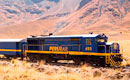
Check train timetables to return to Cusco.
If you plan to stay in Machu Picchu Town (last called Aguas Calientes), the distance from the station of Puente Ruinas to Machu Picchu is 2 Km. It takes around 20 minutes to walk down a narrow path which runs parallel to the train line.
We recommend you check for trains before walking the path.
Inca Trail to Machu Picchu
The Qhapaq Ñan (Cápac Ñan)
The Qhapaq Ñan was declared as World Heritage Site by Unesco (June 2014)
Peru, Argentina, Bolivia, Chile, Colombia and Ecuador share a common cultural heritage of outstanding value: the Qhapaq Ñan, or Main Andean Road.
Two large longitudinal roads make up the Inca road system. A coastal one, from Chile to Tumbes. The other one, paved with stones, was the kingdom’s backbone linking Cusco to Quito through the Highlands. It was equipped with gutters, bridges, containment and defense walls, elevation ramps and stairs in many stretches. The great road or Qhapaq Ñan was at some places 16 meters wide. In other segments the road had two lanes, one paved and wide for the Inca, and the other, a narrow dirt road for the cargo and his assistants. In the southern coast, at Quebrada de la Waca, we can still see a road across the Andes for transporting fish from the Coast to the imperial capital.
Most important among all roads, however, was the so-called Chinchaysuyu road. Built during the reign of Tupac Yupanqui, it was the largest state undertaking during the imperial phase of the Cusco Quechuas, when the Cañari territory and the humid northern highlands were annexed to their social organizations which permitted them to develop an admirable road technology that took advantage of previous designs and that, ironically, was a precious gift to their conquerors.
In its northern portion, the Qhapaq Ñan from Cajamarca to the Ecuadorian province of Loja, the road passed by the Mariviña and bola warehouses. In Cuenca, a place of admirable roads, the largest warehouses were at Tambo Blanco, Tomebamba itself, Paredones and Ingapirca, in the area called Hatun Cañar.
The Incas’ arrival at present-day Ecuadorian territory brought about the transformation of social space. Work was organized following a revolving system for supplying goods and service to all state structures, roads and warehouses. The road’s superb characteristics were constantly maintained through the system described above and rod building during the most recent and highest stage of Inca expansion.
To the south, the roads were those in the contisuyu and the Collasusyu that the Incas split in two, the Umasuyu and the Urcosuyu on the eastern and western borders of Lake Titicaca. Connecting roads linked main ones. Large, circular royal warehouses can be seen along the present border between Arequipa, Puno and Cusco (the Contisuyu and the Collasuyu). A church built on Inca foundations reveals the warehouse was still used in Colonial times for wine and people traveling between Arequipa and Cusco.
Historical information is readily available about this road system such as that related to the technology used in the bridges, traffic, orientation and maintenance system. But there is other less evident information. Journeys were organized so that there would be a tambo or travelers’ inn approximately every 30 Km. Larger royal inns were almost palaces, with warehouses for food and supplies called collcas, meeting halls, and accommodation for permanent service personnel. Chaskiwasis were inns for the foot postmen or chaskis. Other smaller posts were available to wayfarers and postmen. The most reliable estimations put the total number of road inns at somewhat over two thousand. Human energy was administered by Andean society in harmony and balance with a harsh environment. It was a way of measuring and using space that Western knowledge and technology failed to understand and preserve. Studies on the ancient Andean people’s vision of the world and technology could make a valuable contribution to human resource management and adaptation to the natural environment.