Lake Titicaca and Islands
Uros - Taquile - Amantani

The birthplace of the Sun
Sacred place of the Incas and home to natural and artificial islands.
The Lake Titicaca is without doubt one of the most important natural patrimonies of humanity. The importance of the lake in Andean culture is immense: its waters have always meant a source of life for humans, as when the day gets warmer, it creates diverse habitats, that have served through different times as sustenance for humans.
Important lake in Andean mythology, according to the legend, from its waters emerged Manco Capac and Mama Ocllo, sons of the sun god, founders of the Inca Empire.
It's the largest lake in South America and the highest navigable lake in the world, its waters are shared by Peru and Bolivia. In the Peruvian side home to natural and artificial islands, highlighting the floating islands of the Uros, Amantaní, Anapia and Taquile Island an Intangible Cultural Heritage of Humanity (UNESCO). Visits from Puno City
The tourists can make an authentic journey to the past in these islands and share the experiences with the Quechuas or Aymaras natives, even spend the night in their houses. Amazing landscapes, native people with colorful dresses, rich in traditions and festivities. The floating islands of the Uros, Taquile and Amantaní islands offer to tourists an authentic travel to the past, sharing the life with local natives and beautiful landscapes. The tourist are accommodation in a family house and all activities will be with natives. Is a real experience of rural tourism. In these areas visitors come into contact with ancient communities, and have the opportunity to share their ways of life and see their splendid handicrafts.
Close to the port of Puno, and towards the Capachica peninsula, is the Titicaca National Reserve (36,180 hectares), a protected area that time and carelessness have contaminated and that nowadays, is in the process of being recovered. Protects extensive stretches of totora reeds and various species of plants, animals and birds. It is a good place for bird-watchers (endemic birds species)
Its name, deeply significant in local mythology, derives from "Titi" Aymara for cat and "Caca" Quechua for The Sacred Rock on the Island of the Sun. It is located on the Collao plateau. Constitutes the highest navigable lake in the world, 3,812 meters above sea level. It possesses an extension of 8,300 sq. Km, of which 4,966 sq. Km corresponds to Peru and 3,334 sq. Km to Bolivia. It measures 195 Km. length and 65 Km. width and it reaches until 304 m. depth. It presents numerous geographical accidents, 36 islands, some of those inhabited and with archaeological remains. (Map of Lake Titicaca)
Sights and Attractions in Lake Titicaca
Floating islands of the Uros
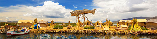
Hundreds of the years ago the Uros people created these floating islands - made of Totora reed - by stacking one reed on top of another until a stable platform was built. They lived on these islands as they sailed around the lake to fish or hunt for their food. You can still see the Uros today, living as if they had floated through time.
There are approximately 63 artificial islands floating in Lake Titicaca (3,810 m.a.s.l.), each inhabited by between 3 and 5 Uro-Ayamara families. A family usually builds its housing, hut knitted in totora (rush or cane), with waterproof roofs against the rain, but existing in its interior great humidity for what is frequent that they suffer from rheumatism at short age. Each family also knits these islands and they are held to the bottom of the lake.
The main islands include Kantati, Flamengo (Flamingo), Pachamama, Suma Wiljpa, Tupiri, Santa María, Tribuna, Toranipata, Chumi and Paraíso (Paradise). The Uros describe themselves as the Kotsuña, "the lake people", with origins that stretch back to pre-Inca times. They still fish in the traditional manner, especially for carachi and the smelt, and they also hunt wild birds. The men are skilled sailors of totora reed rafts and the women are expert weavers. The cold and dry climate, typical of the region, is produced by bodies of water that are constantly evaporating.
The visit to the floating islands of the Uros can be combined with visits to Taquile and or Amantaní Islands in a full day program. Visiting Hours : Mon - Sun: 8.30 am - 5.00 pm., admission fee. Location : 7 Km offshore east of the port of Puno, (20 minutes by boat).
Amantaní Island
An island inhabited by eight communities dedicated specifically to the growing of potatoes, corn, oca, quinoa, broad beans and peas, while typical handicrafts of the area are textiles and stone carvings. Its population is Aymara ethno and is dedicated basically to the agriculture concentrated on the town of Amantaní. It stretches across an area of 9 Km² (3,817 m.a.s.l.), and is characterized by typical flowers from the area like the muña (Andean mint), kantuta, wild sage, tola and patamuña. Among its natural attractions are two viewpoints at the highest point, from which the entire lake can be seen, as well as pre-Hispanic sites, ceremonial centres and a mummies cemetery. Location: 36 Km offshore north-east of Puno port (3 hours 30 minutes by boat).
Rural Tourism in Amantaní
Towards 1970, tourism emerged as an expectation, and the following years worked in favor. Today, in Amantaní a very prestigious project of rural and experienced-based tourism flourishes which charms visitors and improves the local economy.
Amantani has an extension of 9 Km², and its nature is more diverse than that of the other islands: it shows presences of bush plants such as the cantuta, muña, and tola, among others. It has various permanent springs that allow the development of an irrigated agriculture. Furthermore, on its shores the climate is mild, and it creates a habitat apt for combined crops. In Amantaní there are eight communities dedicated to agriculture, subsistence fishing, handicrafts and tourism: Pueblo, Santa Rosa, Lampayuni, Sancayuni, Occosuyo, Incatiana, Villa Orenojon and Colqui Chaqui.
The tourist Project of Amantaní appeared after that of Taquile, therefore, it learned from the former's successes. One of them has consisted on keeping strong the communal bond in the management and provision of services, thanks to which the experience of staying with a family results calm and ordered. The island has many attractions such as the lake scenery and land elevations, which can reach the 4,200 m.a.s.l. (Llacastiti mount). There are also interesting archaeological sites, and definitely, an intense living culture; proof of this is the fact that the traveler has the chance to make contact with some yatiri, which is how the shamans are known in aymara
Taquile Island
The area is known for its friendly people, who still preserve traditional customs and clothes. Among the highlights are the laboriously crafted, fine textiles with symmetric and symbolic patterns, with strong colors that reflect Andean customs and beliefs. Taquile has fertile lands on which inhabit some 300 Quechua families that live keeping their ancestral customs, the manifestations of religious and folkloric habits have a great scenario in Taquile. The men are devoted to the agriculture and the fishing, and the women to the weaving. It is around 6 Km² in size, and the altitude between the port and town varies from 3,810 to 3,950 m.a.s.l., the maximum temperature is 23°C and the minimum is 7°C.
On the island, remains from pre-Inca periods can be found, and can be particularly well observed the higher parts of the island. During the colonial era and until the beginning of the 20th century, the site was used as a political prison, but from 1970 it became the exclusive property of the Taquileans. Located 35 Km offshore east of the Puno port (3 hours by boat) .
Taquile Island Intangible Heritage
On 2005 Taquile Island was proclaimed as "Intangible Cultural Heritage of Humanity" (UNESCO) by its textile art, which is produced as an everyday activity by both men and women, regardless of their age, and worn by all community members.
The weaving tradition on the island goes back to the ancient Inca, Pukara and Colla civilizations, thus keeping alive aspects of pre-Hispanic Andean cultures. Fabrics are either knitted or woven on pre-Hispanic fourstake ground looms.The most characteristic garments are the so-called chullo, a knitted hat with an earflap, and the calendar waistband, a wide woven belt depicting the annual cycles connected to ritual and agricultural activities. The calendar waistband has attracted the interest of many researchers as it depicts elements of the oral tradition of the community and its history. Although new, contemporary symbols and images have been introduced into Taquile textile art, the traditional style and techniques have been maintained.
Rural Tourism in Taquile
Taquile inhabitants integrate the rural community of the same name; they are of Quechua descent, nailed in a mostly Aymara region. Until the 1970 decade, Taquile was a community closed to contact with the exterior world. Little by little, and as a result of the efforts of religious entities, individual promoters and non-governmental organizations, the community began opening to non-traditional tourists who reached the island attracted by the idea of spending some days with the inhabitants, learn from their traditional culture and have the chance to see their textiles. For the people of Taquile tourism has meant a privileged opportunity to improve their economic situation, as agriculture has always been a precarious activity, due to the scarcity of lands and the inaccessibility of markets, and fishing just for self-consumption. Currently, there are multiple possibilities to visit the island and these depend on time, interest and the budget of the traveler. Most tourists do a short trip, which is part of a circuit that includes other islands such as Amantani and Uros. Yet, an important number chooses to spend one or two nights in some family accommodation, which is still a pleasant experience.
Anapia Island
This archipelago is also called Wiñaymarca, which means a location that is always young. This group of islands is located on the minor Lake Titicaca, next to the invisible border with Bolivia. Anapia consists of five islands: Yuspique, Ccaño, Ccana, Anapia and Patahuata. The communities that own the archipielago are Ccaca and Suana. The population of about two hundred families works on agriculture, cattle breeding and fishing. Anapia offers travelers from around the world an extraordinary experience of xperienced-based tourism.
In Anapia, accommodation and meals are provided in their homes, and they have capacity for thirty travelers. There are no lodges or hotels: the essence of the project lies in sharing the life of the locals. The villagers have added a room and a toilet to their homes. The rooms are warm and the beds are covered by warm blankets that allow one to forget about the cold of night. The meals are simple and consist mostly of potatoes, as a great variety of tubers are produced in the archipelago, which then accompany servings of fresh trout and ocas.
Located in the Wiñaymarca or Lesser Lake of Lake Titicaca, the archipelago is populated by inhabitants who follow traditional customs, where fishing is one of the main activities. There are ecological pockets of native flowers, unique in the entire region, abundant fauna and sandy, occasionally stony beaches. Yuspique Island, the largest in the archipelago, is used by the Anapia community for rearing vicuñas. Visitors can see the crops, vicuña farms and archaeological sites as well as experience walks, traditional meals, boat and sailboat trips and folkloric music. Highlights among its traditions include the Challa or “payment to the Earth”; the Cararasiri, a traditional marriage celebrated in the town over the course of three days, in which the entire community participates; and the Rutuchi or “haircut” of recently born children, with the presence of a godfather chosen by the parents who will usually give valuable presents. Located: From Yunguyo 30 minutes by car to Punta Hermosa port. It is 18 km offshore from this port to Anapia island (1 hour 30 minutes by motorboat).
Sun Island (Isla del Sol)
Is an island in the southern part of Lake Titicaca. It is part of the modern Plurinational State of Bolivia. Geographically, the terrain is harsh; it is a rocky, hilly island. There are no motor vehicles or paved roads on the island. The main economic activity of the approximately 800 families on the island is farming, with fishing and tourism augmenting the subsistence economy. Of the several villages, Yumani and Cha'llapampa are the largest. There are over 80 ruins on the island. Most of these date to the Inca period circa the 15h century AD. Archaeologists have discovered evidence that people lived on the island as far back as the third millennium BCE. Many hills on the island contain agricultural terraces, which adapt steep and rocky terrain to agriculture. Among the ruins on the island are the Sacred Rock, a labyrinth-like building called Chicana, Kasa Pata, and Pilco Kaima. In the religion of the Incas, it was believed that the sun god was born here. The Aymara name for the island is Titi'kaka. It is not known what was the original meaning of this word. Some linguists and archaeologists believe the name to be a corruption of Titi (puma) and Kala (rock). In the 1612 Aymara-Spanish dictionary of Ludovico Bertonio, the phrase Tahksi kala is listed as "piedra fundamental" or "foundation stone" possibly alluding to the origin story of the Inca that the Sun and Moon were born in the lake. Accessible from Copacabana, Bolivia
Daily tours from Puno, boarding Catamaran Cruise Ship.
National Reserve of Titicaca
The National Reserve of Titicaca (RNT) is located on the continental waters of Lake Titicaca, it covers 36,180 hectares. Lake Titicaca tours will introduce you to the region's incredible natural beauty and colorful island communities. Wild flora and fauna from Lake Titicaca are preserved in the area. The reserve also contributes to the socio-economic development of the region and maintaining alive the traditional cultures of the people that inhabit the area. The communities of Uros and Uros Titino, which inhabit the islands on the vast lake, offer various hospitality options for tourists, providing an excellent opportunity to soak up the local culture. The reserve protects the lake's great biological diversity, whose most representative species are birds, including the Titicaca duck, and the famous giant Titicaca frog, known as kelli or huankele. The entire length of the Peruvian part of Lake Titicaca was recognized by the Ramsar Convention on January 20th 1997, and it is considered a wetland of international importance, especially as a habitat for aquatic birds.
The reserve is divided in two sectors, one located on the Chucuito bay (Puno sector) and the other to the north, denominated Ramis in the province of Huancané.
The Lake Titicaca harbors numerous species of flora, birds, fish and amphibians, some of them unique in their specie. Special places, excellent choice for the ecological tourism lovers and the observation of these species. In the flora mainly outstands the totora (Quechua voice) (Typha angustifolia) it is a plant with a flat and flexible shaft, reed specie, used in the construction of crafts, houses and artificial islands (See Uros). The totora group is denominated totoral.
Some species of fish native from the lake, as the suche, carachi, pejerrey, boga (Orestias pentlandii), among other, have been threatened and diminished in quantity, due to the artificial introduction of the trout.
In the reserve, dozens of birds, fish, and amphibious species have been registered like flamingos or parihuanas, Andean goose, seagulls, Titicaca grebes, chullumpis and Andean lapwings as well as numerous endemic and endangered species. You will find twelve varieties of aquatic plants representative of the lake flora, the most remarkable being the totora reeds and algae.
Travel to Puno and Lake Titicaca
 |
 |
 |
 |
 |


