Archaeological Places in Nazca

 In Ica department, Andean man from the coast changed the constraints of the desert into life-giving opportunities through enhanced knowledge and technology that allowed him to make the best possible use of harsh water and weather conditions.
Also, the art of these people flooded the monotonous landscape with color and profound enigmas. Ica, the department capital, located 300 Km. south of Lima and 104 Km. north of Nazca City, can be reached along the Pan-American highway. The region can be visited throughout the year, because its warm weather (an annual average of 24°C) is amazingly bright and stable.
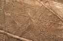
Nazca Lines
These famous huge geoglyphs are located in Pampa Jumana, at about 450 meters above the sea level, in a plain arid zone or esplanade. An enormous network of lines and drawings of animals and plants, attributed to the Nazca culture, covering an area of approximately Km² (135 sq. miles). Some of the best drawings depict hummingbirds, dogs, monkeys and "chaucato", long-tailed mockingbirds. The German María Reiche dedicated 50 years to studying and researching the site and reached the conclusion that it was an astronomical calendar. From a 12-meter (39 feet) viewpoint, the figures of the hand and the tree can be partially observed. However, to fully appreciate the drawings, the area must be flown over by plane. Located in Pampas de San José, 25 Km (16 miles) from Nazca City (15 minutes), between the Kilometer 419 and 465 on the South Pan-American Highway.
Cahuachi

Is located 30 Km / 19 miles western of Nazca City (30 minutes). The Cahuachi ceremonial center Nazca (200 BC - 900 AD) was a major ceremonial center of the Nazca culture. Is the name of one of the most famous pre-Columbian Andean civilizations. Reputed around the whole world for its fine pottery and for the enigmatic lines and figures drawn in the Palpa and San José plains, this culture saw its first development in the Rio Grande basin, about 400 Km south of Lima and many kilometers away from the sea. Cahuachi spreads over 150 Ha of arid hills and dunes. The ancient Nazca people built their pyramidal temples by terracing the fossil sand dunes. In the lowers parts, smaller architectural mounds, streets and squares give the site a general city aspect. However, this is a deceiving appearance because Cahuachi was a ceremonial center, a sacred destination of Nazca pilgrims between 100 and 500 AD.
The ceremonies in the place included the construction of temples using thousands of conical or wedge adobe bricks. Each participating community demonstrated their true belonging to their religious community by singing, dancing and banqueting, thus explaining why in Cahuachi there is little garbage, while offerings abound (pan flutes and musical drums, sacrificed llamas and guinea pigs, fine textiles, human burials and pottery representing deities). The ceremonial site, center of the social, political and religious life of the region, became very busy when the pilgrims arrived at a scheduled date to then recover its peace under the care of the priest and a very small care-taking population. See Antonini Didactic Museum.
CAHUACHI
Palpa Lines
Located at kilometer marker 400 of the South Pan-American Highway. More than 600 geoglyphs, these are enormous zoomorphic and phytomorphic geometric drawings similar to the Nazca Lines and serially overshadowed by the more famous, buy less abundant Nazca Lines. They are located in between the towns of Sacramento, Pinchango, and Llipata. According to recent archaeological studies these lines are older than the Nazca Lines. Represent a series of human and animal zoomorphic figures, including the Familia Real (Royal Family), among which the highlight is the deity of the Paracas culture during late development period (600-100 BC). It is said that 3000 years ago our ancestors used the flat surface of the mountains and the slopes of the hills to draw huge geometric figures, are easier to view from terra firme at lookout Mirador 8 Km. south of Palpa town, approximately 35 minutes north of Nazca City, on the district of Llipata. A small site museum.
Estaquería
Archaeological complex of the Nazca culture, it has been characterized to have series of columns of trunks of huarango, placed on platforms, that were used like solar observatory. This place is near to Cahuachi.
Chauchilla
Is a cemetery that contains prehispanic mummified human remains and archeological artifacts, located 30 kilometers south of Nazca City. The cemetery includes many important burials over a period of 600 to 700 years. The start of the interments was in about 200 AD. It is important as a source of archaeology to Nazca culture. The cemetery has been extensively plundered by huaqueros (grave robbers) who have left human bones and pottery scattered around the area.
Cantayoc Aqueducts
The Nazca valley also has evidence of large hydraulic projects. Taking advantage of the water table, which was close to the ground, the ancient Nazca developed an underground filtering gallery system, known as puquios, to irrigate the areas lacking surface water. These amazing aqueducts are about 620 meters above the sea level on the left side of the river known as Nazca. It seems that the occupation took place in the Regional Developments represented locally by Nazca Culture (±100 - 0 b.C. to 600 a.C.), and they are still in use. This group is represented by a net of underground channels connected to the freatic napa at hundreds of kilometers towards the east, with which, it is shown the Nazcas’ knowledge about aquiferous technique. The construction of Cantayoc aqueducts started with the location of freatic napa. Then, a channel or ditch at certain angle of depth was made. After that, the necessary branches were performed and finally, before they were covered, the necessary vents or “eyes” were made not only as air columns so that the water could run but they also worked as maintenance points. In order to keep it, more investigation is needed. Its importante lies in the fact that it is an integral part of Nazca city and it is still in use and it can be appreciated. Located 4 Km / 2 miles from Nazca City (15 minutes).
Paredones
This group is represented by a set of beaten compressed mud walls that are popularly known as “paredones” (thick walls), distributed in levelling terraces. It is located in the outskirts of Ica city. This archaeological complex is located at about 600 meters above the sea level on the southern skirt of a slight spur of a hill to the route of Nazca city. It is practically placed in an urban area. It seems that the occupation of Paredones took place in the Regional Developments represented locally by Nazca culture (±100 - 0 b.C. to 600 a.C.) but it is notable the occupation in the Regional States with Ica culture (± 900 to 1250 a.C.) and with the incorporation to the II empire or Tahuantisuyo (±1250 to 1532 a.C.). This group is represented by a set of beaten compressed mud walls that are popularly known as “paredones” (thick walls), distributed in levelling terraces. Its architecture uses rectangular adobe bricks on a base of cut stone. It presents a urban planning with common characteristics to these settlements such as a large square of trapezoid floor as a central element, buildings of administrative type, warehouses, barracks, ceremonial or sacrifice area, vigilance tower and others. In some places you can still see the signs of some walls together with cut stones, and in others, the stones present the joint completed united and well fitted, typical of the Inca architecture. This place presents seven sectors, being the best conserved and the most important, sectors IV, V y VII; they present delimited paths for their visit and conservation. Its importance lies in the fact that it is an integral part of Nazca city and it is near the Cantayoc aqueducts. Located Kilometer marker 1 of the Nazca - Puquio Highway (5 minutes from Nazca City).
Travel to Nazca
 |
 |
 |
 |


